THE GREAT PARCHMENT BOOK WEBSITE HAS GONE LIVE!

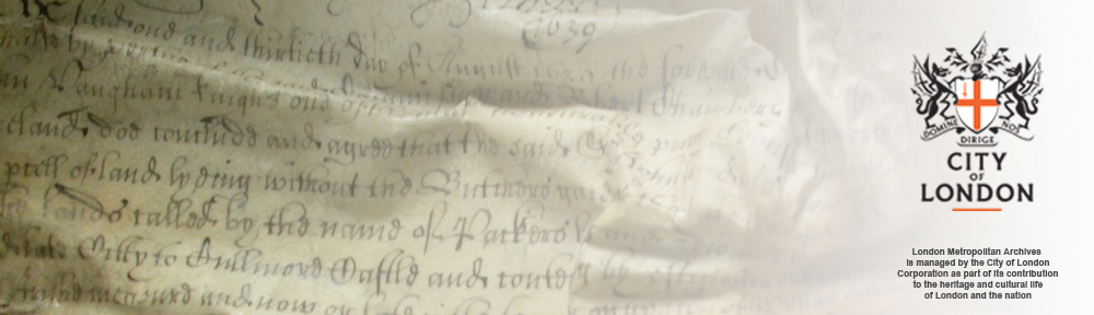
The Great Parchment Book website has gone live!

You can now start to explore the Great Parchment Book for yourself.

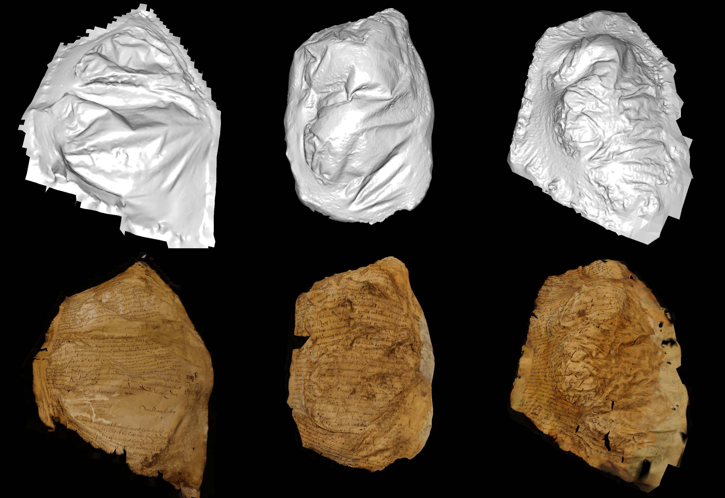
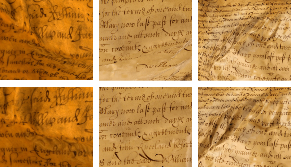
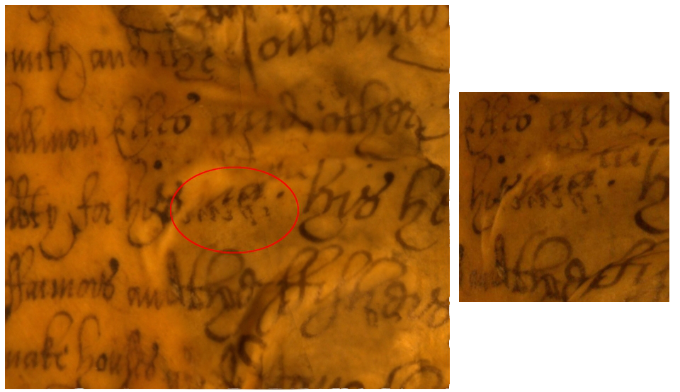
A good place to start is the video on the Home Page which illustrates the challenging nature of the project.

To continue your exploration, click on “Take a look inside the book” or search for a person, place or livery company.

If you want to know more about the historical background, book or project history, investigate the history tabs at the top of the Home Page.

The website is dynamic. Work is continuing on the transcription, and transcriptions and images will continue to be added to the site. Once the transcription is complete, the book history page will be expanded to take account of new insights into the codicology of the book, and to explain the arrangement of the folios.

The Great Parchment Book Blog is now embedded into the website and you can subscribe to the Blog on the website. Work is continuing to align the original Blog and the website Blog.

If you have any comments on the website, or can offer additional insights into the Great Parchment Book and what it reveals about the people, places and organisations involved in the history of 17th century Ulster, please share via the Blog or use the comment form at the bottom of the website Home Page.

The Guildhall exhibition – Plantation: People, Process, Perspectives

The week of the 20th May.

It was an exciting, if very stressful week, as we coordinated the final period of installation of objects and archives for the exhibition.  The exhibition includes a range of objects and archives from the Derry Heritage and Museum Service collection and from national collections in London, Limerick and Dublin.  It’s certainly not a traditional museum exhibition, with a variety of engaging activities and opportunities for all visitors alongside exhibition showcases.  Ever wanted to dress up as Cahir O’Doherty… well now you can!

Staff from the London Metropolitan Archives and the National Archives Kew arrived in the city on Tuesday and installation began on Wednesday morning.  Anyone who has experience of installation will know how nervous it is not only for those travelling with rare and valuable objects but also for the loaning institute staff who are put to the test to ensure the showcases, environmental readings and general exhibition requirements can be met.  But all is well, despite some last minute hitches with stubborn archive drawers, additional mylar straps to ensure no movement of the archives, my colleagues from London worked patiently and diligently to ensure the archives were installed… and look fantastic.

After reading and reviewing the Irish Society collection in the LMA and feeling like I know every line in those familiar early seventeenth century maps of the city it feels we achieved something significant as visitors to the exhibition will see them on display in the city where their journey began.

Next we have objects arriving from the Hunt Museum Limerick and from the National Museum of Ireland collection… as well as a unique piece of textile art from artist Deborah Stockdale!

Exhibition at Derry’s Guildhall opening soon!

Exhibition at Derry’s Guildhall – Plantation: Process, People, Perspectives

Opening in June 2013

Bernadette Walsh Archivist at Derry City Council’s Heritage and Museum’s Service writes:

After many months of researching archive and museum collections, wrestling with start and end dates, what themes to cover and the successful appointment of Museum Designers (Tandem) we now find ourselves just a few weeks away from the opening of the exhibition!

The exhibition will look at the Plantation, how it was planned, how people were effected and what is the legacy today. With Tandem we wanted to explore this particular period of history not only to learn and understand more about our conflicting past but to also allow visitors to the exhibition an opportunity to interact with some of the personalities and problems that developed. It is also an opportunity to showcase a fantastic collection of original maps, drawings and museum objects loaned by national institutions such as the London Metropolitan Archives, the National Archives UK and the National Museum of Ireland.

Plantation Society

The charters in the GBP offer some fascinating insights into the different types of people who lived and held land in the county.  In each grant, the property-holder named is distinguished by their social status, office held, occupation, familial relationships, or a combination of these.  Many of those holding larger pieces of land in the Proportions – single and multiple townlands – were described according to social class: gentlemen, esquires, yeomen, and knights.  On the other hand, most of the people holding land in the town of Coleraine and the city of Londonderry were described according to their occupations: clerks, lawyers, carpenters, sailors, tailors, fellmongers, shoe-makers, glove-makers, innkeepers, barber-surgeons, butchers, brewers, cutlers, tanners, labourers, or according to their office, such as alderman, chamberlain, member of the privy council, or swordbearer.  Women, too, held property by these grants.  Although always described as widows or daughters, these women held land either under their own names or jointly with a man whose relationship to the woman is not often specified or clear.  Some properties are also held jointly by pairs or groups of men, sometimes fathers and sons, sometimes men with other links, such as a group of aldermen, yeomen, or husbandmen.  The names, too, give an indication of whether the land-holder was Irish, English, or Scottish.  While the ‘native’ Irish peasants were originally meant to be displaced and re-settled, the grants in the Book show that some Irish families, in particular the O’Cahans, were granted large amounts of land.

Freedom for the Lord Lieutenant of Ireland

On 26th February, the Lord Lieutenant of the city of Derry, Sir Donal Keegan, was presented with the Freedom of the City of London.  At these occasions, historical objects that are connected to the City and to the recipient are featured, and in this case, a folio of the Great Parchment Book was on display.  This particular folio was from the section dealing with lands held in the city of Londonderry, and generated a great deal of interest in the project and the Great Parchment Book itself. The Great Parchment Book will also feature in the Plantation exhibition at the Derry Guildhall during the city’s 2013 celebrations as the City of Culture, for those who are in the area!

Sir Donal with the folio from the Great Parchment Book

Sir Donal with the folio from the Great Parchment Book

Sir Donal with Paul Double (The Remembrancer)

Sir Donal with Paul Double (The Remembrancer)

(L to R)  Catherine McGuinness and Richard Regan (Past Deputy Governors of The Irish Society), Sir Donal, Alderman Ian Luder (current Governor of The Irish Society)

(L to R) Catherine McGuinness and Richard Regan (Past Deputy Governors of The Irish Society), Sir Donal, Alderman Ian Luder (current Governor of The Irish Society)

(L to R) Murray Craig (Clerk of the Chamberlain’s Court), Sir Donal, Ernest Brocklehurst (Beadle to the Chamberlain

(L to R) Murray Craig (Clerk of the Chamberlain’s Court), Sir Donal, Ernest Brocklehurst (Beadle to the Chamberlain

Exploring and Flattening Parchments Interactively

We recently had our paper, Interactive Exploration and Flattening of Deformed Historical Documents, accepted for publication in the Computer Graphics Forum and to be presented at Eurographics 2013.

Our procedure begins by capturing a set of high resolution photographs of the pages of the book, and generating from them a detailed 3D scan of each page. Typically we need between 40 and 60 images per folio to capture every fold and crease in sufficient detail. Using these scans we attempt to “virtually restore” the pages and produce undistorted images of the pages.

Three pages of the Great Parchment Book. Top: our reconstructed surface model. Bottom: the models textured with images of the text. The surface models show the level of distortion the parchment has suffered, which differs greatly from folio to folio.

Three pages of the Great Parchment Book. Top: our reconstructed surface model. Bottom: the models textured with images of the text. The surface models show the level of distortion the parchment has suffered, which differs greatly from folio to folio.

Having generated scans for the majority of the pages in the book, we realized that producing a globally flattened and undistorted image of a page is not always possible for the more damaged pages due to the sheer variety and complexity of the deformations present.

To get around this problem we instead created an interactive browser application, effectively a “Google Earth for documents”. Google Earth allows users to navigate over the surface of the earth following lines of latitude and longitude, and always see a locally flat map of the region of the earth they are looking at. In a similar way, our viewer allows users to navigate over the surface of the page following lines of text, and see a locally undistorted image of the region of the page currently in view. One of the key insights here is that flattening multiple small, local regions of a page is much simpler than flattening the entire page at once.

Sections of text before and after the local flattening procedure

Regions of text before and after the local flattening procedure

We also understand the importance in the digital cultural heritage field of being able to trust digital representations of artifacts. To help users gauge the quality of the reconstruction and be more confident in what they read, our application includes a “provenance feature” which allows them to compare the 3D scan and the original photographs which were used to generate the scan. For every point on the scan surface, the application can display an original input photograph next to it which allows the user to verify what they are seeing in the scan.

Left: A region of a reconstruction of a page, containing a suspect marking which looks like it might have been introduced by an error in the reconstruction process. Right: One of the original photographs, looking at the same region of the page. We can see that the marking is in fact present on the page.

Left: A region of a reconstruction of a page, containing a suspect marking which looks like it might have been introduced by an error in the reconstruction process. Right: One of the original photographs, looking at the same region of the page. We can see that the marking is in fact present on the page.

Our application will soon be used as an additional tool for the transcription of the Great Parchment Book and possibly later as a means of dissemination of the book’s content.

Landholdings

As the transcription of the Great Parchment Book continues, a range of types of landholdings is becoming apparent.  The charters in the Book are largely grouped  according to the Livery Company holding the land, but there are also sections for lands held in the city of Londonderry and the town of Coleraine, and for those lands held by the ‘native’ Irish. These charters grant a variety of holdings, ranging from ‘smale parcalls’ measured in perches to urban tenements to townlands covering hundreds of acres.  Although there is reference to specific parishes, albeit the use of the term ‘parish’ is rare, and to churches, vicarages, and chapels in a more general sense, so far there has been no mention of lands granted to any church, nor has anyone been instructed to build or maintain any churches.

Those properties held in the city of Londonderry and the town of Coleraine are often specified as being on a specific street. Londonderry had four main streets: Gracious Street, Queens Street/Bishopsgate Street, Silver Street, and Shambles Street. This last was also known as Butchers Street or Butchers Row as the term ‘shambles’ refers to either stalls to sell meat or a place to slaughter animals.  At least one butcher, James O’Gallagher, is recorded with a holding on Butchers Street, however, the only slaughter-house mentioned is found on Gracious Street and belonged to a cutler called John Knox. 

The properties in Londonderry and Coleraine were not strictly urban, since they also included a ‘backside’ or back-yard and garden of unspecified size, and often a piece of land in the Liberties of Londonderry or Coleraine, or in the Island of Derry.  The Island of Derry refers to the hill upon which Londonderry is located, surrounded by the River Foyle and an area known as ‘The Bog’ which was at one time under water but had become marshy and silted up by the seventeenth century.  The Liberties of Londonderry and Coleraine extended for a distance of three miles on all sides, and some of the holdings located in these areas were much larger, up to a few hundred acres.

The largest holdings, however, are found in the Proportions held by the various Livery Companies.  Each Proportion was divided into townlands which varied in size. The majority of the landholders were granted a single townland, but a number held multiple townlands comprising, sometimes, thousands of acres.

Great Parchment Book blog read around the World in 2012

WordPress.com stats prepared a 2012 annual report for this blog.

The Great Parchment Book blog got about 9,400 views in 2012 from all over the World. Click here to see the complete report.

Puzzling Place Names

The Great Parchment Book contains many types of places used in different contexts. Land in Northern Ireland was divided into counties, parishes, and townlands of varying sizes, and it is the townland designation that is largely used in the Great Parchment Book to describe which pieces of land are held.  However, there are also other sorts of places named including estates, manors, castles, towns, streets, mountains, bogs, rivers… Once the place names have been transcribed – and they are not always obvious, especially when part of the name is missing or illegible – we have to decide what ‘type’ of a place it is and then identify the modern equivalent if possible since anyone searching for a specific place will use the modern terminology. Of course, there is also no guarantee that both the current and the Great Parchment Book place names refer to the same place. For example, folio G2v mentions the two townlands of ‘Lismakerell Bogge and Lismakerell Moore’ but there is currently only one townland called Lismacarol. In addition, the name as found in the Great Parchment Book may not exactly match modern place names and some deciphering may be necessary: Tarquiny vs Tirkeeveny; Moymucklemurray vs Moy mc Gillwory; Mullagh vs Meola. Some of the place names are used to identify landholders, such as William Wray of the city of Dublin; Radcliffe Kirk of Blessingbourne in the county of Tyrone; and Edward Hill of Farsetmore in the county of Donegal. Helpfully, Dublin, Tyron, and Donegal have been specified a bit further, and a quick search on the internet reveals that Blessingbourne refers to an estate and Farsetmore is a townland.  However, some names refer to many types of places. Coleraine is a town, a parish, and a townland, while Londonderry is a county and a city, and these are not always specified. One can only hope that the writers of the book knew which places they were talking about!

Beginning the transcription

Now that the conservation work is completed, we have begun the transcription and encoding of the folios. We are beginning with the six folios on the Goldsmiths’ proportion and will use these to plan out the website and the particulars of the encoding into XML using TEI. But first they have to be transcribed!

The text itself is formulaic, which means that it is usually possible to fill in the text missing from those areas that are illegible, burnt, shrunken, torn, or covered in dirt. This also means that the transcription involves much rereading of the folios to fill in the gaps, but it is very satisfying to have a complete transcription.

Whilst the text itself is in English, there are lots of varieties in the spelling (for example, the use of ‘howse’, ‘fower’, ‘cabbyns’) so we are going to include a modernised transcription on the website, with modernised spelling, punctuation, and names (as far as is possible). We also plan for the website to include a glossary of terms that may be unknown or not immediately obvious to the reader, such as ‘quicksett’ and ‘fireboot’. The place names present extra challenges as some of the names mentioned correspond to current Northern Irish place names, but some of them do not. In addition, there is no guarantee that the 1639 boundaries of places such as townlands and counties correspond to the modern ones. Fortunately, the script itself is a large, neat, clear, secretary hand, and this makes the transcription a little easier.